[Back Post] Kyushu with Momiji, Day 7: Sakurajima
 |
| Momiji enjoying the view of Sakurajima at Arimura Lava Observatory, Sakurajima. |
Day 7 of our Kyushu road trip was also a fine and sunny day. In high spirits, we set out from Kirishima for our day trip to Sakurajima, off Kagoshima Bay.
 |
| Hundred Years Cedar Garden, Kirishima Hotel. |
Just after checking out of Kirishima Hotel, we briefly popped by the Hundred Years Cedar Garden (Jp link)(Google Maps), which was next door to the hotel. The garden is so-named because of the cedars are over 100 years old.
 |
| Hundred Years Cedar Garden, Kirishima Hotel. |
Nurtured for generations, trees were planted by Horikiri Buemon, the founder of Kirishima-kan (the hotel's predecessor).
 |
| Hundred Years Cedar Garden, Kirishima Hotel. |
There was no one else in the cedar garden, and it was tranquil and quiet. Rather eerily so. I lingered for a short while before making my way back towards the small shrine at the entrance, and back down to the car park below.
 |
| Maruo Falls, Kirishima (on IG). |
Along the way to Sakurajima, we made another brief stop. This time at Maruo Falls (Google Maps), a hot spring waterfall not far from Kirishima Hotel. It's about 23m tall and 16m wide, and is a rare hot spring waterfall, with the waters from Iodani Onsen. Unfortunately they were doing some rebuilding works, so we were not able to get to the viewing platform at the base of the waterfall. From a distance though, the view was still lovely. I was rather fascinated with how the water looked as it cascaded over the columnar joints on the cliff face, with the spray catching the light.
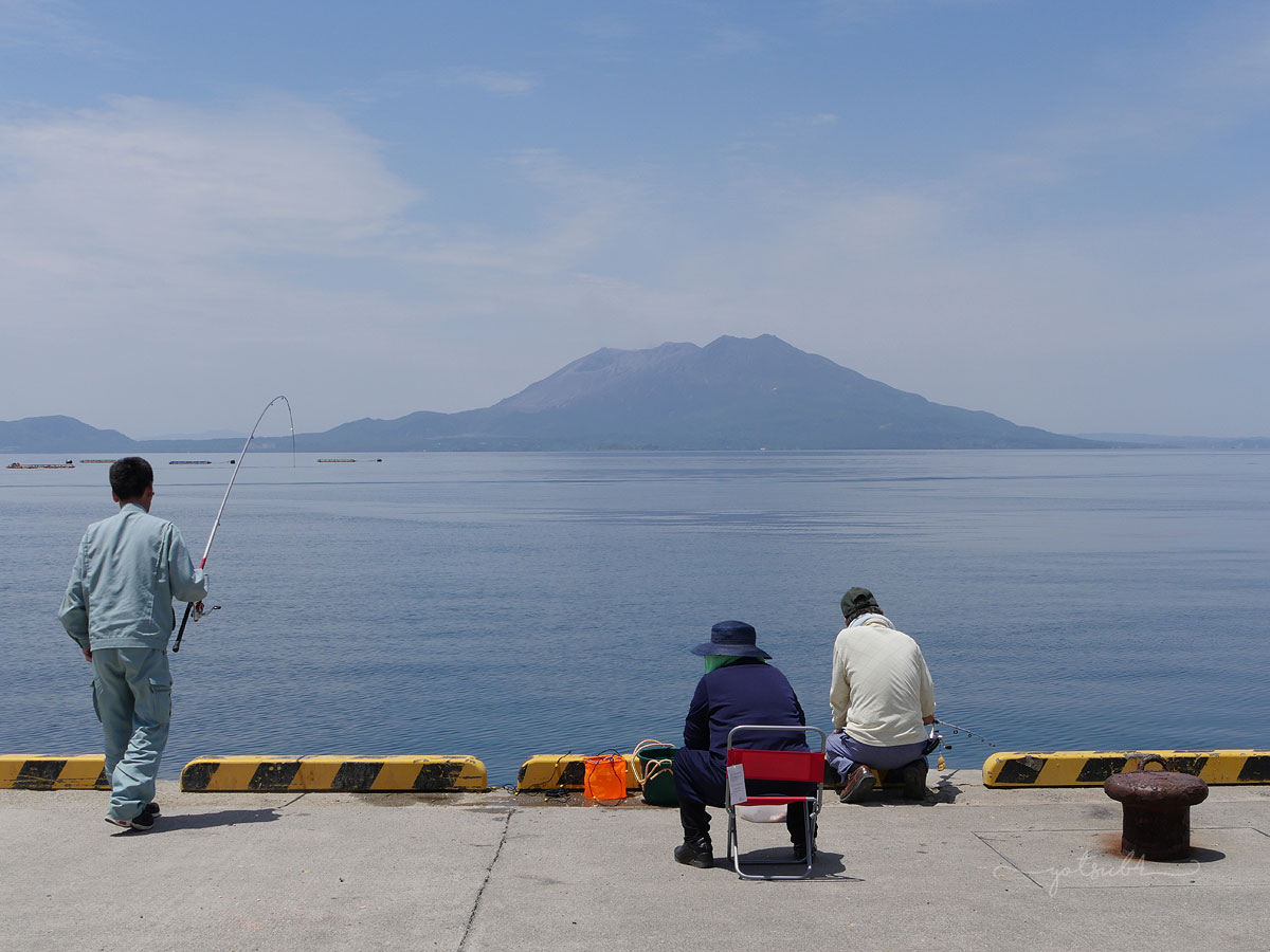 |
| Townsfolk fishing with Sakurajima as their view. |
Not too long en route, we started seeing views of Sakurajima. As mentioned (here), Sakurajima is a symbol of Kagoshima. It is one of Japan's most active volcanoes, and one of the world's most active. Despite several hundred minor eruptions taking place every year, Sakurajima is reportedly due for another major eruption soon. With such an active volcano right at their doorstep, I'm pretty amazed that daily life continues so normally for the people living in Kagoshima Bay area. They even nonchalantly fish with it in plain sight!
 |
| Sakurajima, en route via Route 220. |
Sakurajima is a stratovolcano on the south rim of the Aira caldera, and is also a part of the Kirishima-Kinkowan National Park. Around 13,000 years old, Sakurajima was once an island, and had been dormant for over a century. But on 11 January 1914, following several large earthquakes which prompted residents of the area to evacuate, Sakurajima exploded in a major eruption that changed the Kagoshima Bay area. Between 12th and 13th January 1914, further earthquakes and eruptions took place, and the massive lava flows continued for months. It is claimed that around 10 billion tons of lava flowed from that eruption. The lava flows swallowed up several smaller islands in the bay, made the bay shallower, and formed a narrow strip of land that connected Sakurajima to the mainland. It was this connecting strip of land that we now drove across from Kagoshima to Sakurajima.
 |
| Momiji free climbing at Arimura Lava Observatory, Sakurajima (on IG). |
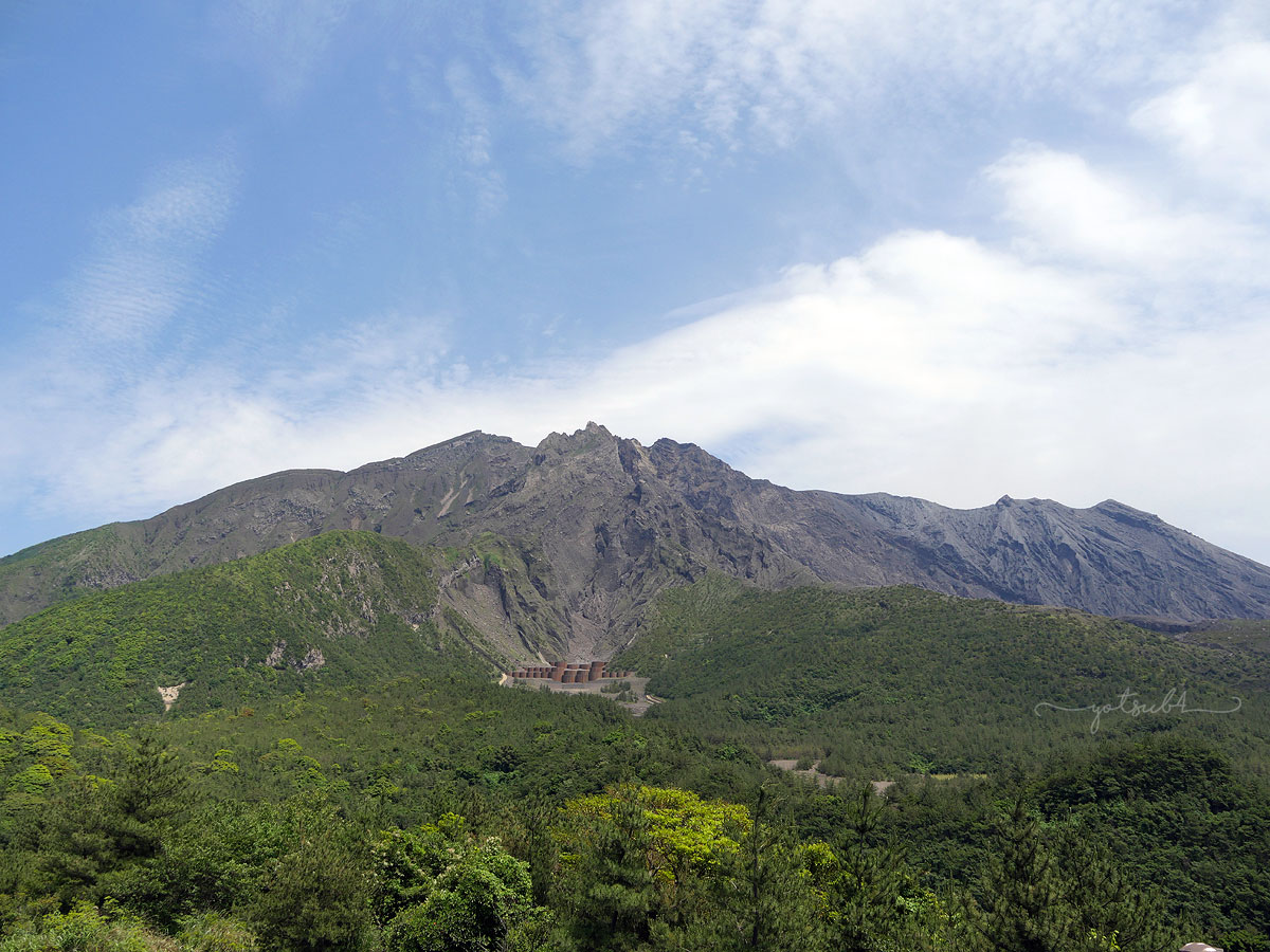
Our first sightseeing stop was the Arimura Lava Observatory (Google Maps), on the southern end of Sakurajima. The observatory is on a lava field that was created in the 1914 eruption mentioned above. Walking along the promenade path at Arimura, we were treated to panoramic views of the lava fields from the 1914 eruption, as well as views of Sakurajima's Showa Crater, on the eastern slope of its southern peak, Minami-dake.
 |
| Showa Crater, Sakurajima, Arimura Lava Observatory, Sakurajima |
At its highest, Sakurajima is 1,117m above sea level, and is around 50m in circumference. Sakurajima has 3 main peaks: Kita-dake, Naka-dake and Minami-dake (literally "north peak", "central peak" and "south peak" respectively). Minami-dake has been the most active peak since 1955, and many eruptions have taken place from the Showa Crater since 2006.
 |
| Sakurajima, Yunohira Observatory |
We also stopped by the more popular Yunohira Observatory (Google Maps), located on the western flank of Sakurajima. The Yunohira point is the highest on Sakurajima (373m), and it is the closest to the Showa crater at 2.5km. By this time, some fluffy clouds had rolled in and so it was hard to see the smoke rising from the crater. Nonetheless, Sakurajima still made for a breathtaking sight. Maybe a little less ominous, but its bare summit is still a stark reminder. From wherever we stood, the dark slopes of the volcano's summit was bare of vegetation, naked as can be.
 |
| Kagoshima and Kinko Bay from Yunohiro Observatory, Sakurajima |
Besides the view of Sakurajima's summit, Yunohira also has sweeping views of the city of Kagoshima and Kinko Bay (the other name for Kagoshima Bay).
 |
| Tsukiyomi Shrine, Sakurajima |
On our way down from Yunohira, we decided to have a quick stop at the Tsukiyomi Shrine (Google Maps) which was founded around 708-715 AD. Tsukiyomi Shrine is the island's main shrine, and the current shrine was rebuilt in its present location after the original was covered by lava during the 1914 eruption. The shrine's main deity is Tsukuyomi-no-mikoto, the kami of the moon. The shrine also enshrines Konohanasakuya-hime, the spouse of Ninigi-no-mikoto (his story is already mentioned in Day 5 on Takachiho). Both Konohanasakuya-hime and Ninigi-no-mikoto are also enshrined in Kirishima Shrine, which we visited on Day 6. It is speculated that Konohanasakuya-hime is the namesake for Sakurajima, which may be plausible because of her name, and the story of her protecting her children from fire.
We did not stay very long as it was a small shrine. (That said, the shrine is the biggest on Sakurajima.) And after our brief visit, we stopped for lunch at Ofukuro-no-Aji Shun, a no-frills restaurant within the Hinoshima Megumi-kan rest stop (Google Maps).
 |
| My Hinoshima Gozen lunch set at Hinoshima Megumikan, Sakurajima. |
Hubby opted to have the Kurobuta ramen while I chose the more luxurious Hinoshima Gozen set meal. My meal was a delicious collection of dishes featuring Kagoshima specialties, and foods produced on Sakurajima. The main dish of my lunch set was the Kagoshima kurobuta which is, as mentioned before on Day 6, the pride of Kagoshima. So, it was done tonkotsu-ni style (pork bone stew), with konnyaku, local brown sugar, miso, the famed Sakurajima daikon, and Sakuajima spring onions. The kurobuta meat was so tender that it fell off the bone. Apparently another way it is prepared in Kagoshima is by simmering in shochu. The various side dishes featured Kagoshima food specialties: satsuma-imo tempura, kibinago fried and marinated in vinegar, satsuma-age. (Curiously, satsuma-age is called tsukuge in Kagoshima, but satsuma-age everywhere else in Japan). The pickles were also Sakurajima daikon.
Speaking of the Sakurajima daikon, I wanted to get one and bring it home to cook, as a souvenir. Being the biggest in the world, it's size would be a huge novelty, but apparently it tastes good too. Sadly, I couldn't find a fresh one as it's not the right season (it's harvested in January and February).
 |
| Hubby's Sakurajima komikan jelly. |
Sakurajima is also known for the Sakurajima komikan. My lunch set obviously had this local produce too: Sakurajima komikan salad dressing, as well as a small glass of amanatsu-mikan juice, both made by Sakurajima Shunsaikan (the restaurant's main company). Hubby's ramen set also had juice and a small slice of komikan jelly, which I filched from his tray.
After lunch, we stopped by the Karasujima viewpoint (Google Maps), another lookout point located on the western side of Sakurajima. The area was once an island (called Karasujima) that was 500m off the shore, but was engulfed and became part of Sakurajima due to the lava flow from the 1914 eruption. After this spot, we walked the Nagisa Lava Trail (Google Maps), a 3km promenade along the coastline.
 |
| Momiji at the Nagisa Lava Trail, Sakurajima |
 |
| Behind-the-scenes at Nagisa Lava Trail, Sakurajima. |
The clouds around the summit of Sakurajima had cleared up over lunch, and we could clearly see the smoke from the Showa Crater. Personally I think the views of Sakurajima at the Arimura and Yunohira viewing points were much better. But the view of Kagoshima Bay from the promenade was also very scenic.
 |
| Nagisa Lava Trail, Sakurajima (on IG) |
 |
| Nagisa Lava Trail, Sakurajima |
The Nagisa Lava Trail cuts through the lava fields created in the 1914 eruption. Walking along, we could see the rough, dark brown volcanic rock covering the landscape, parts of it covered with grasses and short scrubby plants. The view of Kinko Bay was also rather scenic, especially the parts where we could see the volcanic rocks spilling out over the coast into the water.
 |
| Nagisa Park foot bath |
At the end of the Nagisa laval trail, we got to the Nagisa Park Foot Bath (Google Maps) where we stopped to soak our tired feet into the public onsen foot baths, free of charge. The foot bath was about 100m long, filled with cloudy onsen water (heated by Sakurajima of course). From the wooden seats, we were able to enjoy the views of the bay on one side, and the peaks of Sakurajima on the other. At the initial dip, the onsen water felt super hot and we both felt like our feet were being cooked. It didn't feel like that at the Tsutate Onsen foot bath (see Day 3). Anyway, we bore it and stayed in until our feet got accustomed to the heat. After that, it felt so good that we just didn't want to get out anymore!
We did get out eventually, as we had decided to make a last stop, a brief visit to the Kurokami buried torii (Google Maps) on the east side of Sakurajima.
 |
| The Kurokami buried torii gate, Sakurajima. |
 |
| Information board (with questionable English) at the Kurokami burried torii gate, Sakurajima. |
It was deserted while we were there. Not surprising, as it's rather off the beaten track, and is not really a sight to be fussed about. The spot is basically a stone torii gate that was buried by volcanic pumice and ash during the 1914 eruption, leaving only 3m of the torii visible.
 |
| A typical evacuation shelter in Sakurajima, to protect people from volcanic debris. |
 |
| Evacuation shelters dotted all around Sakurajima, to protect people from volcanic debris. |
Going around Sakurajima, we spot shelters dotted all around the island. The shelters were erected as emergency shelters for people on the island, to take refuge from the volcanic ash and debris during eruptions. Volcanic ash is such an everyday part of life in Sakurajima that the tombs and grave stones on the island are covered by corrugated iron or plastic roof shelters.
 |
| Catching the Sakurajima Ferry back to the mainland. |
We decided to return to the mainland earlier than our original plan. And so we caught a ride on the Sakurajima Ferry from the Sakurajima Ferry Terminal. As Hubby drove our tiny car up the ramp to the ferry, it brought back some nostalgic memories of our early days vacationing together. It has been a long time since we got onto a ferry with a car. The last time was in 2008 on a visit to Fraser Island (a trip that happened in my pre-Blythe mommy days).
 |
| Looking back to Sakurajima as we head to Kagoshima. |
 |
| Looking forward to Kagoshima, on the Sakurajima Ferry. |
The ferry ride is a fairly short one, around 15 to 20 minutes. But still ample time to lounge around and check out the views as we headed for the mainland.
 |
| Udon noodle bar on the Sakurajima Ferry. |
There was even an udon noodle bar on board the ferry! Sadly, we did not have a bowl, as we were both not hungry at all and didn't really want to force ourselves. In any event, we had a good dinner planned ahead, and looked forward to that instead — having Kagoshima wagyu, said to be one of Japan's best wagyu, yakiniku style at Gyudo! (Google Maps).
 |
| Kagoshima wagyu beef for our yakiniku dinner at Gyudo!, Kagoshima. |
Onto Day 8, the highlight of our Kyushu trip: Yakushima!
Kyushu with Momiji, May 2019✈️ Day 0 • Singapore - Tokyo - Fukuoka🚗 Day 1. Saga Prefecture (Route) • Yutoku Inari Shrine (Kashima) • Takezaki Kaisan (Tara) • Shiibasansou (Ureshino) 🚗 Day 2. Yame (Route) • Kitaya Brewery • Shutei Gin no Ka • Iwatoyama Kofun • Yame Traditional Craftwork Centre • Yame tea plantations • Yabe no Mori 🚗 Day 3. Kumamoto Prefecture (Route) • Tsuetate Onsen • Nabegadaki Falls • Ikeyama Suigen • Sozankyo 🚗 Day 4. Aso (Route) • Kusasenri • Daikanbo • Akaushidon Iwasaki • KAI Aso 🚗 Day 5. Takachiho (Route) • Takachiho Gorge • Takachiho Shrine • Ama no Iwato Shrine • Ama no Yasugawara Shrine (skipped) • Kunimigaoka (skipped) • Solest Takachiho • Restaurant Nagomi 🚗 Day 6. Aso & Kirishima (Route) • Kusasenri • Ramen Keika, Kumamoto • Kirishima Shrine • Kirishima Hotel 🚗 Day 7. Sakurajima (Route) • 100-Year Cedar Garden • Maruo Falls • Arimura Lava Observatory • Yunohira Viewpoint • Tsukiyomi Shrine • Sakurajima Michi-no-Eki Rest Stop, Hinoshima Megumikan • Karasujima Viewpoint • Nagisa Lava Trail • Nagisa Park Foot Baths • Kurokami Shrine • Kurokami Viewpoint • Sakurajima Ferry • Kagoshima wagyu at Gyudo! ✈️ Day 8. Yakushima (Route) • Yakusugi Museum • Ryujin no Taki • Senpiro no Taki • Tsukasaki Tidal Pool • Ohko no Taki • Seibu Rindo • Yakushima Seaside Hotel 🚗 Day 9. Yakushima (Route) • Shiratani Unsuikyo • Hachimanju Cha-en ✈️ Day 10. Yakushima & Kagoshima (Route) • Suginoya • Yakushima Airport • Kurobuta tonkatsu at Mansaku, Aira • Miyama District (Miyama Toyukan & Chin Jukan Touen) • Shiroyama Viewpoint • Richmond Hotel Kagoshima Tenmonkan • Ramen Kuroiwa 🚗 Day 11. Kagoshima to Fukuoka (Route) • Sengan-en • Teru-zushi, Kitakyushu 🚅 Day 12. Fukuoka (Route) • Kushida Shrine • Hakata Traditional Craft and Design Museum • Hakata Riverain • Tenpyodo • Iwataya Annex • Canal City Hakata (Shodai Hidechan at Ramen Stadium, Hamleys) ✈️ Day 13. Tokyo • Hoshinoya Tokyo • Shopping • Sushi Nanba Asagaya ✈️ Day 14. Tokyo - Singapore • Sushi Kimura * * * |
Comments
Post a Comment
Thank you for stopping by. I would love to hear from you, and I believe it is important to have a respectful and open-minded environment in which to express our views. Different views are welcome; abuse, hate speech and cyberbullying are not. Freedom of speech does not justify the unacceptable.